Updates for Boundary, Arrow, Kootenay Lake fire zones

By Nelson Daily Staff
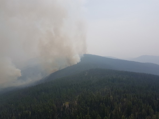
Two wildfires in the Arrow region are being closely monitored by BC Wildfire Service crews the Southeast Fire Centre said in a media release Wednesday.
The South of Renata Creek blaze and Santa Rosa wildfire are both being closely monitored as BC Wildfire Service is prioritizing these new fires and responding to them accordingly
The two Arrow fires add to a handful of which are of note in the Boundary, Arrow and Kootenay Lake fire zones.
South of Renata Creek wildfire:
- The South of Renata Creek wildfire is in the Bulldog Mountain area, about five kilometres south of Renata.
- This fire currently covers about 72 hectares and is being closely monitored.
- As a precautionary measure and in the interest of public safety, the Regional District of Central Kootenay has issued an evacuation alert for nine addresses located south of Renata on Lower Arrow Lake. For more information about this evacuation alert, visit the Regional District of Central Kootenay website: https://www.rdck.ca
Santa Rosa wildfire:
- The Santa Rosa wildfire is burning in the United States about 800 metres south of the Canada-United States border, about nine kilometres southeast of Castle Mountain and about 22 kilometres southwest of Rossland.
- This fire covers about 337 hectares (832 acres), and 301 U.S. Forest Service personnel are working on site today.
- Additional information on this fire is available online: https://inciweb.nwcg.gov/incident/6088/
- As a precautionary measure and in the interest of public safety, the Regional District of Kootenay Boundary has issued an evacuation alert for properties in the Big Sheep Creek drainage and for properties east of the two-kilometre mark on the Santa Rosa Road. For more information about this evacuation alert, please contact the Regional District of Kootenay Boundary at 250 368-0259 or visit its website: https://www.rdkb.com
McArthur Creek wildfire:
- The McArthur Creek wildfire is in the Mount Waldie area, about 13 kilometres southeast of Salmo and about nine kilometres east of Highway 6. This fire covers about 206 hectares and is being closely monitored.
- As a precautionary measure and in the interest of public safety, the Regional District of Central Kootenay has implemented an evacuation order for the Sheep Creek Road area southeast of Salmo. For more information about this evacuation order, please call the Regional District of Central Kootenay at 250 352-7701 or visit its website:https://www.rdck.ca
Blacktail Mountain wildfire:
- The Blacktail Mountain wildfire is west of Kokanee Glacier Park, about eight kilometres southeast of Silverton. This fire currently covers about 1,898 hectares and is being actively monitored as a modified response fire.
Toronto Creek wildfire:
- The Toronto Creek wildfire is about 12 kilometres north of downtown Grand Forks and about two kilometres east of Granby Road. This fire covers about 11 hectares and is 70% contained.
- Eight personnel are on site today, assisted by air support and heavy equipment.
- The Regional District of Kootenay Boundary has issued an evacuation alert for properties along Granby Road and Volcanic Creek Road. For more information about this evacuation alert, please call the Regional District of Kootenay Boundary at 250 368-0259 or visit its website: https://www.rdkb.com
Lynch Creek wildfire:
- The Lynch Creek wildfire is about 25 kilometres north of downtown Grand Forks and about two kilometres northeast of North Fork Road.
- This fire currently covers about 50 hectares. Fifteen personnel are on site today, supported by four helicopters and heavy equipment.
- As a precautionary measure and in the interest of public safety, the Regional District of Kootenay Boundary has issued an evacuation alert for all properties along North Fork Road between the junction of Miller Creek Forest Service Road and the 34-kilometre mark on the North Fork Road. For more information about this evacuation alert, please contact the Regional District of Kootenay Boundary at 250 368-0259 or visit its website at
- https://www.rdkb.com
Randal Creek wildfire:
- The Randal Creek wildfire is about 17 kilometres southeast of Yahk near the Canada-United States border, and covers about 905 hectares.
- Twenty-three personnel are on site today, assisted by air support.
- The Regional District of East Kootenay has issued an evacuation alert for the Yahk, Meadow Creek Road and Highway 3/95 area. For more information about this evacuation alert, please call the Regional District of East Kootenay at 250 426-2188 or visit its website:www.rdek.bc.ca
Blazed Creek wildfire:
- The Blazed Creek wildfire is about two kilometres north of Highway 3 and about 26 kilometres northwest of Creston, and covers about 5,188 hectares.
- BC Wildfire Service personnel are on site. With the aid of air support and heavy equipment, they are working to protect powerlines and the Highway 3 corridor.
- Motorists should watch out for smoke and rolling debris from this fire. For current highway information, visit:www.drivebc.ca
There have been 87 new wildfire starts in the Southeast Fire Centre since Aug. 11, 2018, 49 of which are in the Boundary, Arrow and Kootenay Lake fire zones.Currently, 158 fires are burning within the Southeast Fire Centre’s jurisdiction. Since April 1, 2018, 373 fires have burned 29,559 hectares.
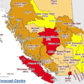
Fire danger ratings in the region are expected to increase with hot and dry weather in the forecast for later this week. To report a wildfire or open burning violation, call 1 800 663-5555 toll-free or *5555 on a cellphone.
For the latest information on current wildfire activity, burning restrictions, road closures and air-quality advisories, visit: bcwildfire.ca