UPDATED: First Snowfall Warning in the books, chance of flurries on the horizon

By Nelson Daily Staff
The southern interior is digging out after the first major snow storm of the season.
And Old Man Winter is expected to stick around for at least a few more days with Environment Canada forecasting a chance of snow flurries for the next few days.
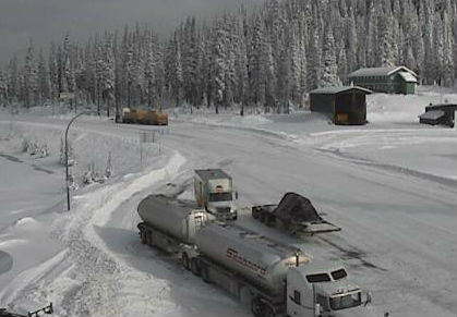
Many of the mountain passes were hit hard by the storm, with 36 cm falling on the Okanagan Connector through the night.
Roads in and around the West Kootenay/Boundary were slick with numerous accidents and fenderbenders to start the winter driving season.
Winter weather will stick around into the weekend though, with temperatures hovering around 0 C.
Road conditions are available at DriveBC.
Weather Statement upgraded to Snowfall Warning
That Special Weather Statement issued Wednesday by Environment Canada for Highway 3 – Paulson Summit to Kootenay Pass just got kicked up a notch Thursday.
Environment Canada has upgraded the warning now to a Snowfall Warning for Highway 3 – Paulson Summit to Kootenay Pass, with total amounts of 20 to 30 cm is expected.
“A significant snowfall is forecast across the southern interior today due to the presence of a low pressure system over the south coast and the passage of an arctic front,” Environment Canada said.
“The snow will be wet or mixed with rain in some valleys before turning to all snow later today. Total snowfall amounts will range from 10 to 15 cm in the valley bottoms to 20 cm or more over higher terrain. The snow will ease to a few flurries by midnight tonight over the southwest interior and by Friday morning in the Kootenays.”
Environment Canada said heavy snow will occur across the southern interior highway passes Thursday. Total snowfall accumulations of 20 to 30 cm are expected before the snow tapers off tonight.
The weather may cause visibility to be suddenly reduced at times in heavy snow as rapidly accumulating snow makes travel difficult.
Commuters can expect poor weather conditions to contribute to transportation delays.
“Weather in the mountains can change suddenly resulting in hazardous driving conditions,” Environment Canada said.
ShiftIntoWinter.ca reminds drivers to know before you go. Adjust to winter driving behaviour and use winter tires and chains.
Road conditions are available at DriveBC.
Old Man Winter making an early trip to Southern Interior
Don’t let the sunshine fool you.
Environment Canada issued a Special Weather Statement Wednesday for Highway 3 — Paulson Summit to Kootenay Pass due to a Wintery Mix of weather fopr Thursday across the southwest interior.
“An arctic front will move across the southwest interior on Thursday,” the Environment Canada website said.
“Ahead of the front snow will develop overnight across most regions of the southwest interior. Across the interior highway passes 10 to 15 cm of snow is likely overnight Wednesday and Thursday.”
Environment Canada said for most communities in the southwest interior valleys, there is significant uncertainty with the precipitation type, whether rain or snow will fall. Kamloops, Salmon Arm, and the north Okanagan will see precipitation phase changes as the Arctic front moves across the region southwards.
Anyone driving is advised to please closely monitor Environment and Climate Change Canada for the latest updated forecasts.
“Weather in the mountains can change suddenly resulting in hazardous driving conditions,” Environment Canada said.
Road conditions are available at DriveBC.
The public should continue to monitor alerts and forecasts issued by Environment Canada.
To report severe weather, send an email to ec.tempetepacifique-pacificstorm.ec@canada.ca or tweet reports using #BCStorm.