Let the good times roll: lake levels continue to rise as flood waters surge, but snowpack drops below normal

By Timothy Schafer Local Journalism Initiative Reporter
The level of Kootenay Lake could rise as much as five feet within the next two weeks while the snowpack is dropping lower than normal, according to recently released data from FortisBC and the Ministry of Forests.
With unseasonably hot temperatures hovering above 30 degrees Celsius for daytime highs the meltwater flowing into creeks, rivers and Kootenay Lake is higher than normal for this time of the year, according to FortisBC.
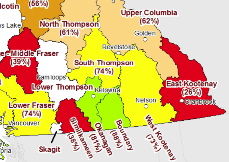
On the other end of the scale, the snowpack has dropped to 73 per cent of normal for this time of year (as of May 15) — from a solid position of 94 per cent of normal two weeks ago — recorded through data from the B.C. River Forecast Centre’s (RFC) Snow Survey and Water Supply Bulletin.
Based on the automated snow weather stations throughout the West Kootenay region, on average, 100 per cent of the annual snow pack typically accumulates by April 15, but by May 15 the provincial snow pack averages a melt rate of 17 per cent of the total snow pack.
This year, the total snow pack melted 43 per cent by mid-month across the province and the region. But this isn’t a sign of flood danger, the RFC noted.
“Due to the rapid, ongoing melt, the May 15 snow pack measurements should not be considered a reliable indicator of flood hazard,” it began. “Instead, they reflect general patterns of melt and approximate remaining water storage in snow pack, providing an early indicator of areas that may have heightened susceptibility to summer drought and water availability concerns.”
And, although much of the region’s snow pack is depleted — which reduces the flood risk from snowmelt — the flood risk from heavy rainfall remains high in many areas since river systems currently undergoing high flows from snowmelt are vulnerable to “flow amplification” from rainfall.
Warnings and advisories
The Slocan River is currently under a flood watch warning by the B.C. River Forecast Centre and all other areas of the RDCK remain under a high streamflow advisory.
FortisBC issued an advisory late last week that lake levels could increase by as much as five feet within the next two weeks.
“Lake levels are predominately driven by natural inflows as a result of melting snow pack and precipitation, and are subject to sudden, large increases,” noted a press release from the Regional District of Central Kootenay.
For the most current information and to sign up for lake level notices, visit www.fortisbc.com/lakelevel.
Longer view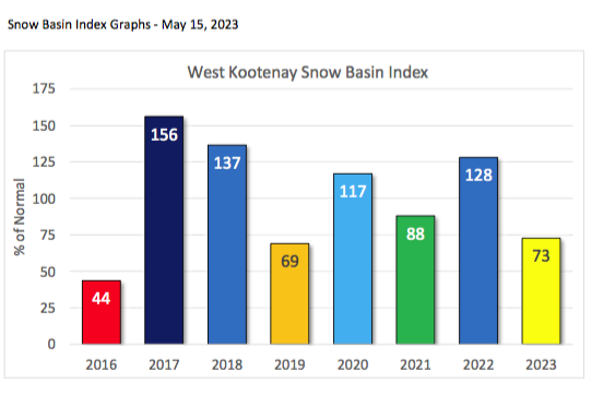
As of May 15 the provincial snow pack was substantially below normal, averaging 66 per cent across B.C. — contrasting with the May 1 recording of 91 per cent.
“Currently, many rivers are experiencing the highest flows of 2023 to date, and in some cases, the highest flows on record for this time of year. However, the widespread risk of ongoing snowmelt related flooding has dissipated due to the quick depletion of the provincial snow pack,” noted the B.C. Rivers Forecast Centre.
Last year, the May 15 average of all snow stations in British Columbia was 128 per cent of normal.
“Snow basin indices are lower this year compared to last year due to contrasting weather patterns in early May. In 2022, cool and unsettled weather conditions presided over the province into late spring and substantially delayed snowmelt,” the RFC noted.
El Niño phase
The extremely hot, seasonal record-breaking temperatures across the province in early to mid-May could signify the end of the past three years of “triple-dip” La Niña cycles, possibly heralding the arrival of an El Niño phase.
“The Climate Prediction Centre (CPC) is currently maintaining an El Niño Watch, with El Niño conditions likely to develop within the next few months and likely persisting (greater than 90 per cent chance) into the winter,” the RFC said.
El Niño is the warm phase of the El Niño southern oscillation (ENSO), with global average temperatures tending to be higher in El Niño years than in La Niña or ENSO-neutral years.
“Seasonal weather forecasts from late April indicate a greater likelihood of above normal temperatures for almost all of B.C. from May through July,” the RFC stated. “Precipitation, which is more difficult than temperature to predict at a seasonal scale, is currently forecast to have a greater likelihood of … wetter than normal conditions for areas in the” West Kootenay.
Source: Snow Survey and Water Supply Bulletin
Kootenay Lake level monitoring
The level of Kootenay Lake is vital to operating four hydroelectric dams on the Kootenay River.
“We monitor the lake levels throughout the year, which are governed by the 1938 International Joint Commission order on Kootenay Lake,” noted the FortisBC website on Kootenay Lake levels.
“The International Joint Commission administers the Boundary Water Treaty of 1909 between Canada and the United States, which provides regulations and resolves disputes concerning waters that flow along or across the international border, like the Kootenay Lake watershed.”
Source: FortisBC lake levels monitoring
Annual Kootenay Lake operations
Sept. 1 – Jan. 7: the maximum geodetic elevation is 1,745.32 feet.
Jan. 7 – Jan. 31: the elevation gradually declines to a maximum of 1,744.00 feet.
Jan. 31 – Feb. 28: the elevation gradually declines to a maximum of 1,742.40 feet.
Feb. 28 – March 31: The elevation gradually drops to a maximum of 1,739.32 feet.
After March 31: Rise in lake endeavour to keep the elevation below 1,739.32 feet.
Source: FortisBC