Environment Canada issues Special Weather Statement as temperatures rise

By Lone Sheep Publishing
It’s early into the summer season, and already Mother Nature is turning up the heat.
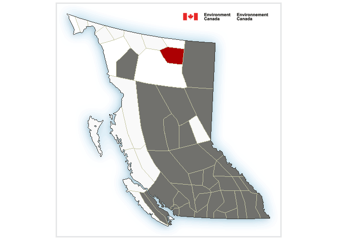
Environment Canada has issued a Special Weather Statement for most of BC, including the Boundary/West Kootenay region as the first stretch of hot weather is forecast to being Saturday and into early next week.
“The BC Interior will experience its first stretch of warmer than average temperatures beginning this weekend,” the Environment Canada website said.
“On Saturday, temperatures will reach into the upper 20s.”
“For the remainder of the weekend and early next week, temperatures will rise into the low to mid 30s,” Environment Canada added.
“Overnight lows will fall to the mid-teens.”
Environment Canada said daytime highs with rise into the low to mid 30s with overnight lows down to the mid-teens.
Environment Canada said with elevated temperatures, the risk of heat related illnesses increases.
The rise in temperatures should also impact freezing levels rise throughout this event, causing an increase in snowmelt and snowpack instability — increased stream flows due to run-off are possible.
For more information on river flows, check out the British Columbia River Forecast Centre and Avalanche Canada.
Emergency Preparedness Resources:
- River Forecast Centre
- Current Flood Warning and Advisories
- Current Streamflow Conditions and Flood Forecast Modeling
- Sign up for RDCK Emergency Notification System to receive notifications
- RDKC Emergency Management
- Emergency Management – Prepared BC
- Prepared BC emergency guides and resources
- Landslide and Flooding Risk Due to Wildfires – Ministry of Forests
- Public Weather Alerts
- Drive BC