100-year mark: B.C. River Forecast Centre drops historic flood watch advisory on region

By Timothy Schafer Local Journalism Initiative Reporter
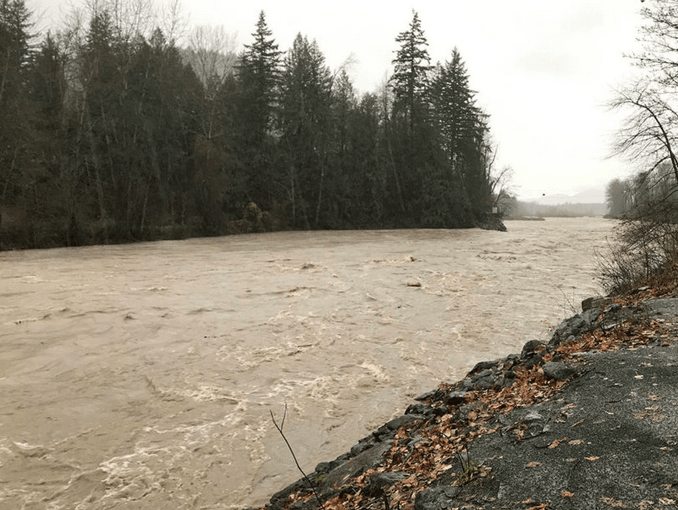
Water flows are predicted to hit the 100-year mark or higher by the weekend in the West Kootenay-Boundary as high temperatures continue and significant precipitation is expected later this week, according to the province’s flood watchdog.
The B.C. River Forecast Centre issued an upgraded flood watch for the West Kootenay-Boundary region on May 2 with flows hitting up to a 10-year range by Friday and compounding by the time the weekend settles in.
“Additional rises — 20-year to 100-year flows or higher — are possible on Saturday and Sunday, depending on precipitation amounts later this week,” the report stated.
Rivers have already begun rising in a hurry throughout the region since the end of April. That last weekend of April saw a rapid snowmelt take place at mid elevations, with daily rates of melt in the 20-40 millimetre (mm) range, the centre reported.
“Snowpack ripening is being observed at upper elevations, and with continuing hot temperatures through this week, snowmelt runoff is expected to increase substantially,” the report read.
The continued high temperatures coupled with significant rainfall later this week means on-going rises in rivers and streams are expected across the region, with increasing potential for flood hazard over the coming days.
“The potential for heavier precipitation on Friday and Saturday could lead to a period of significant flood hazard through the region late this week,” the report warned.
This warning includes areas around the southern portions of the West Kootenay-Boundary and in watersheds draining mid-to-high elevations, including the Kettle River, Granby River, Moyie River, Salmo River and similar rivers and tributaries.
Weather synopsis
Sunny conditions with warm temperatures and high freezing levels are anticipated through this week, the centre noted.
Despite the spring season, daily high temperatures are going to be unseasonably warm, in the upper-20°C to low-30°C range through to Thursday.
“On Thursday the ridge of high pressure is forecast to weaken, with an upper low trough approaching B.C. on Friday, bringing precipitation to the region,” the report predicted.
“There is currently uncertainty on the location and severity of potential rainfall late in the week, with current forecasting indicating the potential for significant amounts of precipitation — 30-60 mm — in areas.”
Taking it to the bank
River levels are rising or expected to rise rapidly. Being near these riverbanks, creeks and fast- flowing bodies of water is dangerous. Here are some points to remember:
• stay clear of fast-flowing rivers and potentially unstable riverbanks;
• avoid recreational activities such as fishing, swimming, boating or hiking near high streamflow rivers or streams;
• high streamflow can easily trap strong swimmers, increasing risk of drowning.
Beyond the bank
During a high streamflow advisory, conditions can change quickly. People can understand the risks and get prepared by visiting www.PreparedBC/floods.
How high is high?
A high streamflow advisory means that river levels are rising or expected to rise rapidly, but that no major flooding is expected.
Fast-flowing bodies of water increase risk to life safety, with minor flooding in low-lying areas possible.
A flood watch means that river levels are rising and will approach or may exceed bank full. Flooding of areas adjacent to affected rivers may occur.
A flood warning means that river levels have exceeded bank full or will exceed bank full imminently, and that flooding of areas adjacent to the rivers affected will result.
Source: B.C. Rivers Forecast Centre
Snow conditions commentary
Temperatures were primarily seasonal to below seasonal through April until the final weekend of the month.
A high pressure ridge developed over the province, setting many daily maximum temperature records from April 28-30, with the recent hot weather kick starting the snowmelt season.
The provincial snow pack is near normal — with the West Kootenay steady at 90 per cent — with the provincial average for the snow measuring sites at 97 per cent.
By April 15, on average, 100 per cent of the total seasonal snowpack has accumulated in a typical year. By May 1, typically about four per cent of the seasonal snow pack has melted. Based on the data, the date of maximum snow occurred on April 24, with approximately 8.5 per cent of the snow pack melted by May 1.
Source: May 1 Snow and Water Supply Bulletin