Highway 6 near Silverton closed due to Aylwin, Komonko Creek wildfires

By The Nelson Daily Staff
Wildfires south of Silverton has forced the closure of Highway 6 Saturday.
The DriveBC website said 11.5 kilometers of Highway 6 has been closed to traffic for both local and responder safety, with no estimated time of opening due to local wildfires in the Slocan Valley. Anyone travelling in this area can detour on Highway 31A, Highway 31 and Highway 3A with an additional one hour driving time.
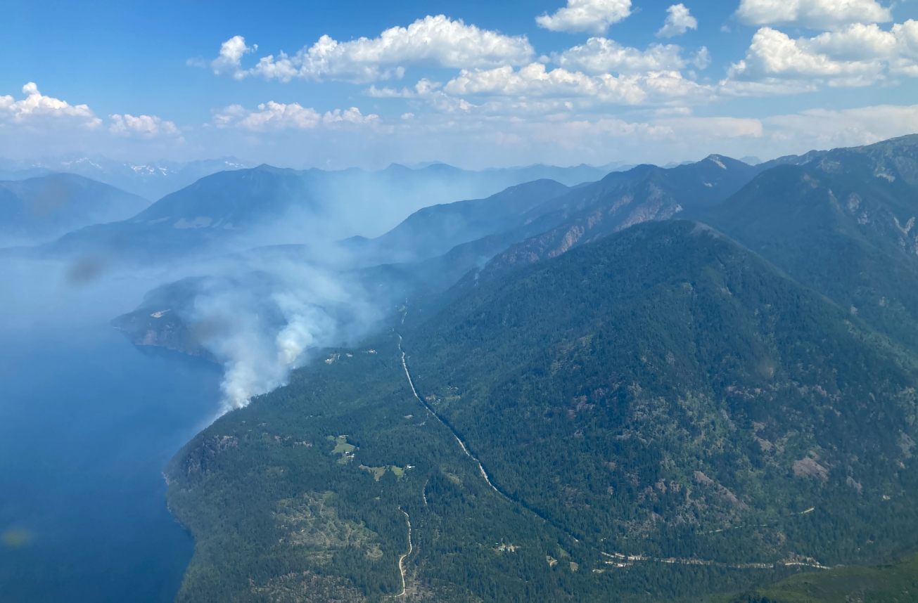
Currently two major out-of-control and lightning caused wildfires — Aylwin Creek (121 hectares) and Komonko Creek (534 hectares) are burning on both sides of Highway 6 south of Silverton.
The Aylwin Creek wildfire has forced the Regional District of Central Kootenay to issue an evacuation order and alert for properties in the area.
See the RDCK website for more information and a list of properties.
The BC Wildfire Service said that two-unit crews and response officers continue to work on this fire.
However, smoke in the area has reduced visibility which has hampered aircraft assault of the fire.
BC Wildfire Service said helicopters will support suppression efforts when visibility improves.
Currently, BC Wildfire Service said the Aylwin Creek wildfire fire behaviour Saturday morning was rank 2 with pockets of rank 3 — which means it is a low-moderately vigorous surface fire with visible open flame.
Structure protection crews worked through Friday night focused on areas of concern.
Also in the Slocan Valley, the Nemo Creek 1 and 2 wildfires were discovered on the west shore of Slocan Lake on Thursday, July 18 in Electoral Area H. The fires merged and BCWS is now referring to this fire as Nemo Creek. As of July 20 the fire is estimated to be 823ha in size, the cause of this fire is suspected to be lightning.
The RDCK on the recommendation of the BCWS, the RDCK issued an Evacuation Order on Thursday, July 19 for 21 waterfront parcels on the west shore of Slocan lake in Electoral Area H, and a small portion of Valhalla Provincial Park.
The RDCK said that this Order remains in place and the public is advised the area is not accessible to enter and asks the public torespect this order and follow the signage that has been placed along the shore of the area under Order.
The Nemo Creek fire is burning upslope and is considered inoperable terrain. BCWS is monitoring fire behaviour throughout the day.
Meanwhile, closer to Nelson, BC Wildfire crews have been working diligently to control the 12 hectare size Eagle Creek fire west of Nelson above the community of Blewett.
BC Wildfire Service said skimmers, air tankers using retardant, and helicopters supported the response efforts late Friday evening and Saturday morning using local water sources on the seven-hectare, lightning caused fire.
Saturday evening, BC Wildfire Service gave this update regarding the Eagle Creek fire:
- Hoselay is wrapped around the perimeter of the fire and a wetline is nearing completion.
- Aviation resources have completed objectives but will be available to support if required.
- Crews continue suppression efforts focused on priority objectives.
BC Wildfire Service said that high temperatures continue to be above seasonal across the province contributing to hot and dry conditions with more than 30 active heat warnings have been issued in B.C. Minimal precipitation is expected in the north with isolated thundershowers lingering through the Northwest and Prince George Fire Centre.
With no rainfall in the southern regions the fire danger rating is between high to extreme in most areas.
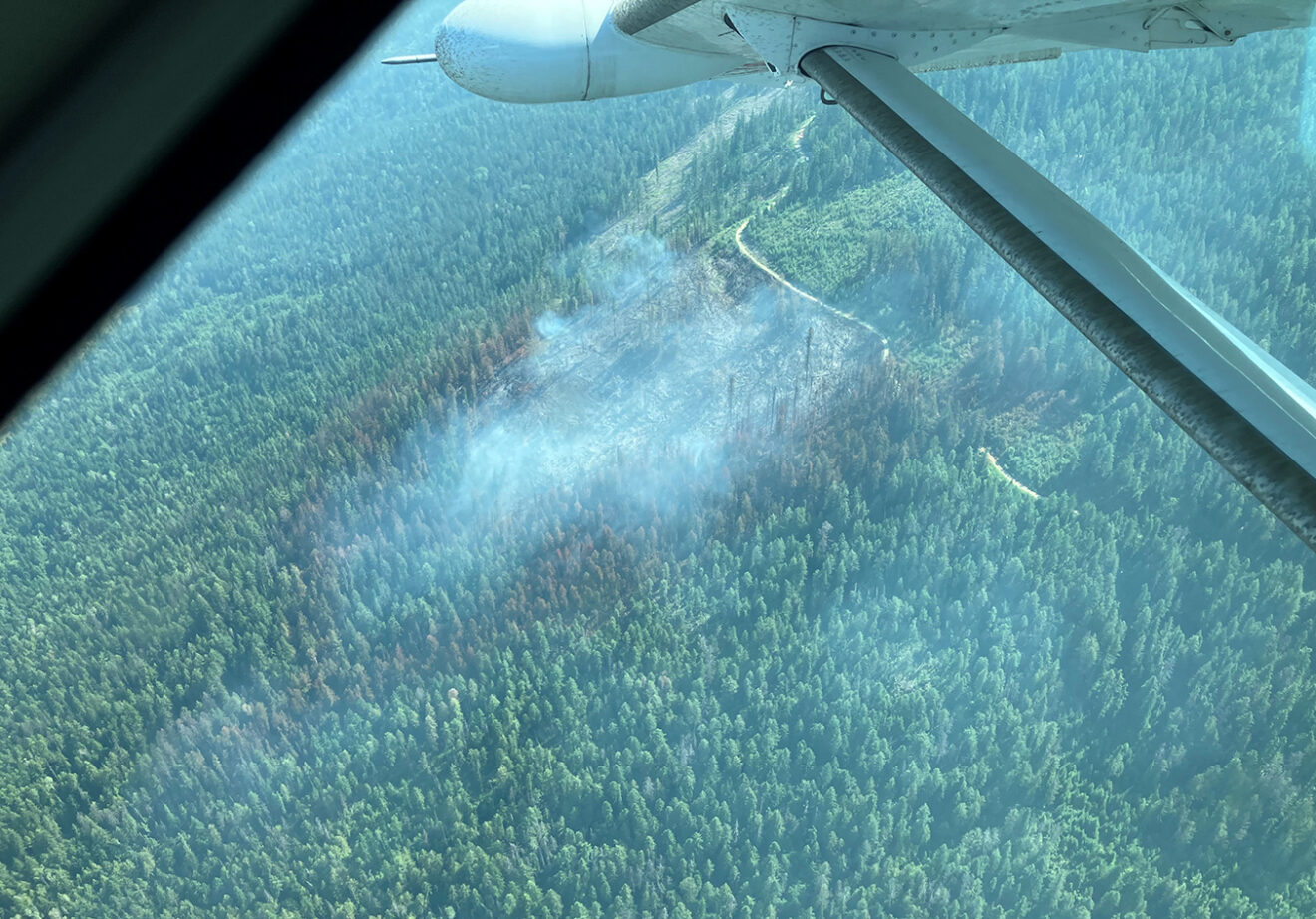
The BC Wildfire Service aerial assault Saturday put a major dent in the Eagle Creek fire west of Nelson near Blewett. — BC Wildfire Service photo