‘Considerable’ avalanche conditions persist, but are slowing: Avalanche Canada

By Timothy Schafer Local Journalism Initiative Reporter
Although avalanche conditions remain considerable in the West Kootenay backcountry there are reports that show a ‘slowing of avalanche activity,’ according to an Avalanche Canada forecaster.
Colin Garritty, lead field tech and forecaster with Avalanche Canada (AC), said, despite the slowing of activity, there were several significant avalanche incidents within the latest gathering of field information.
“(L)ike an anomalous natural size two near Ymir peak that may have failed on the early January surface hoar, considering its distance from the natural cycle on the weekend,” he noted in his report. “A vehicle in the southern Valhalla (range) triggered a size 1.5 on this layer as well.”
Earlier this week the backcountry weather had improved enough for better visibility after the “widespread natural avalanche activity that occurred last weekend. Many of these avalanches failed on the early January surface hoar.”
Since the previous weather cycle there has been “explosive control” that included large, deep, persistent slab avalanches triggered up to size three and storm slabs to size two.
“Human triggering and remote triggering remain possible, with 1,700-2,100 metres and east-to-northeast aspects being the critical elevation band and aspects for the early January layer,” Garritty wrote.
However, recent snowfall in the backcountry has been activating a persistent weak layer 50-60 centimetres deep.
“In many cases, this interface has been even more reactive than the new snow interface above it. Additional flurries and ridgetop wind will keep this problem near its tipping point in the coming days.”
Uncertainty about the snowpack in the West Kootenay backcountry is due to the fact that persistent slabs are particularly difficult to forecast, Garritty explained.
“The snowpack contains deep, human-triggerable weak layers that have steadily been producing large, destructive avalanches. Keep up the conservative terrain selection regardless of what surface conditions tell you,” he said.
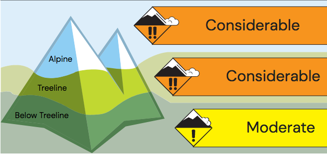
Avalanche conditions are rated as “considerable” at the treeline for the next three days, and also remain considerable into the alpine in the region this Friday, easing to moderate on Saturday, but back into considerable again on Sunday.
Below the treeline the avalanche danger is moderate.
Snowpack summary
There is a sheath of new snow throughout the region on all aspects and elevations, with up to 10 cm having fallen on a “thin rime” crust of snow, said Garritty.
“This will be an interface to watch with the next snowfall and/or wind loading,” he said. “Including the new snow, about 30-40 cm now has been settling and bonding to a mix of wind-affected and sheltered low-density storm snow above about 1,700 m and a rain crust at lower elevations.”
A failure plane that has caused many avalanches in the region has been developing, as a weak layer of surface hoar now sits preserved 50 to 70 cm deep, especially prevalent in sheltered terrain at treeline, Garritty explained.
A facet/crust layer is down 60-90 cm (and two to 10 cm thick at TL elevation). Below this, the mid-pack is settled and consolidated.
A concerning and weak layer of facets and crust 20-50 cm thick make up the basal snowpack.
Source: Avalanche Canada
• Weather details can be found in the Mountain Weather Forecast.
Travel and terrain advice
Be aware of the potential for surprisingly large avalanches due to deeply buried weak layers.
Carefully assess open slopes and convex rolls where buried surface hoar may be preserved.
In areas where deep persistent slabs may exist, avoid shallow or variable depth snowpacks and unsupported terrain features.
Wind slabs are most reactive during their formation.
Source: Avalanche Canada