UPDATED: Kootenay Lake Levels Not Expected to Rise Beyond Current Level

By Nelson Daily Staff
It appears the Heritage City has dodged the flooding scare said a City of Nelson media release Wednesday.
Last week, City staff anticipated that lake levels in Nelson could rise another 12 -18 inches from its current level with the peak expected between Wednesday and Friday of this week.
However, due to a much of the lower and mid-range snow levels having melted over the past number of weeks and the arrival of cooler temperatures, it appears that Kootenay Lake levels have peaked and will start to slowly decline over the next week or so staff said.
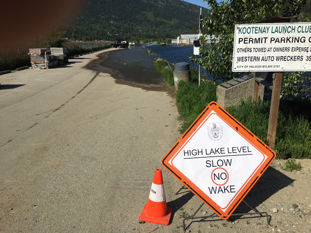
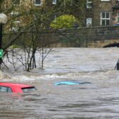
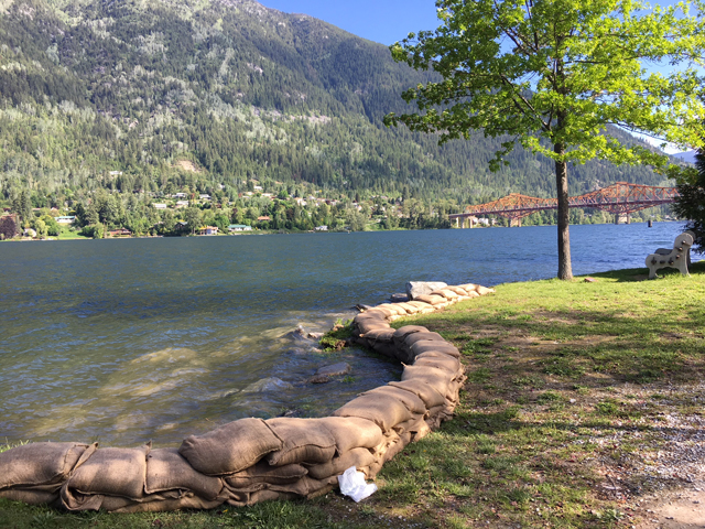
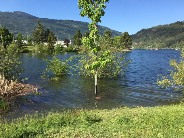
According to Fortis BC, lake levels reached 1752.2 feet (534.07 meters) at Queens Bay and have most likely peaked, even though last week they were expecting that we could see levels meeting or exceeding those in 2012 of 1753.8 feet (534.56 meters).
“This is great news," says Fire Chief Len MacCharles in the release.
“As long as we don’t see any significant storms with heavy rainfall, we are unlikely to surpass the current lake levels and that’s good for everybody. We just need enough precipitation to keep the nearby forests from becoming too dry and susceptible to wildfire”.
Chris Gainham, Manager of Municipal Services for the City of Nelson said staff can now focus on much of the usual work for this time of year.
Craig Stanley, Supervisor of Public Works and Parks, is happy to report that although the sports field users had all been contacted with the potential of seeing some of the fields unusable during the anticipated high water, it is looking like that might not be the case.
Despite the good news, City staff is still advising the public use caution around all creeks banks and shorelines for safety and to protect the environment.
City of Nelson continues to monitor rising Kootenay Lake levels
City of Nelson staff is gearing up for an increase to the level of Kootenay Lake due to warmer than usual seasonal temperatures coupled with natural inflows of a significantly above average snow pack.
On Friday (May 25th) FortisBC forecasted an increase of the level of Kootenay lake to exceed 1753 feet (534.3 meters) at Queens Bay by the end of May.
“In 2012, (Kootenay) lake reached the highest level since 1974 at 1753.8 ft (534.58 meters), and it is likely we will see similar lake levels this year,” said Nelson Fire Chief Len MacCharles in a media release.
“The City has taken a number of proactive steps since 2012 to help minimize the impacts of high water but we will still see some impacts. Our primary goals right now are public safety and protection of property and the environment.”
City staff anticipates that lake levels in Nelson could rise another 12 -18 inches from its current level with the peak expected between Wednesday May 30th and Friday June 1st.
However, MacCharles said conditions could change drastically if the region, or city watershed, sees a significant increase in rainfall during the next few weeks.
For safety reasons, City staff is asking everyone to stay away from the lakeshore and along the banks of creeks until the water recedes.
Staff has also observed that natural wave action is eroding sections of the dog walk. As the water rises more areas that are normally high and dry will be prone to erosion.
“We are asking that boaters maintain “no wake” speed all along the lake to avoid damaging the unprotected shoreline and personal property,” City staff said.
In 2012, water from Kootenay Lake flooded the ball diamonds at Lakeside Park. To delay any potential flooding, staff has sandbagged the lower areas along the waterfront pathway.
“We’re assessing the sports fields at Lakeside Park frequently,” said new Supervisor of Parks and Public Works, Craig Stanley. “We’ve met with the user groups and RDCK recreation management staff, to let them know we could be required to the close fields with minimal notice.”
Stanley said the fields are close, the City would inform the user groups and the community of the closure through email, the City’s website (nelson.ca), and social media.
“Plans to reschedule games to other venues have been discussed with the user groups,” he said.
Environment Canada forecast for the coming week sees this high pressure being pushed out early in the week with a chance of showers Monday through Friday. Temperatures will drop back to seasonable highs of around 20 C.
In spite of the pending high water in Kootenay Lake, Nelson council would like reassure residents and businesses it doesn’t anticipate any disruption to traffic flow down Lakeside Drive.
“Our small business owners rely on all of us to support them and we encourage residents and visitors to shop at their favourite stores along Lakeside Drive and Hall Street,” said Nelson Mayor Deb Kozak. “It is business as usual.”
Public Safety:
- Stay away from the lake shoreline
- Stay away from creek banks
- Remove personal property near creeks
- Don’t walk or drive through standing or flowing water
- Be cautious when boating – there is a lot of debris in water and water remains very cold
- Call 911 for all emergencies
Public areas currently or expected to be impacted by predicted lake levels:
- Dog walk between Prestige Lakeside Resort and west end of Airport (Currently Closed)
- Kootenay Launch Club parking adjacent to Prestige Lakeside Resort
- Sports Fields and Pathway near Lakeside Park
- Tramway Car Barn / Tramway
- John’s Walk pathway
- There may be other areas affected depending on extent of lake levels
Some of the actions taken by City staff to mitigate the impacts of flooding in Nelson:
- Activated Nelson Emergency Operations Centre to monitor creek and lake levels and to coordinate mitigation and response needs
- Ongoing checking and clearing obstructions and blockages from over 60 culverts, creek crossings and priority catch-basins two to three times daily to reduce the risk of overland flooding
- Ongoing monitoring of water levels and impacts at various locations, participating in information sessions with EMBC, BC Hydro, FortisBC and US Corp of Engineers
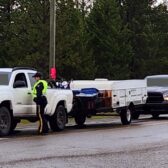
- Placement of sandbags at key locations throughout the city
- Sand and bags placed under Orange bridge for public use
- Completed flushing and debris removal from key locations in the stormwater system including the Duck Bay outfall.
- Sealing of dozens of sanitary manholes along lakeside that are susceptible to inflow of stormwater/floodwater. Sealing the manhole pick-holes reduces the potential for water to enter the system that can impact the integrity of the wastewater treatment plant and can reduce the risk of basement flooding
- Met with sports field users and RDCK recreation staff, Streetcar Society, Prestige Resort + Marina, Columbia Wireless, Kootenay Launch Club, High Terrain to discuss the impact of high lake levels
- As an ongoing project the City typically completes approximately 3 km of sanitary sewer lining via trenchless methods each year. This lining not only restores the structural integrity of the pipes but reduces the infiltration of groundwater and stormwater into the sanitary sewer system that can have a negative impact on the wastewater treatment plant.
- Engaged an engineering consultant to undertake a shoreline erosion and needs assessment. This work will identify shoreline improvements that can reduce the impact of high water damage on the Nelson shoreline.
- SNC Lavalin Flood Risk Assessment, Flood Mapping and Flood Mitigation Planning for the City – Report due for completion December 2018
- Initial flood mapping review to identify impacts at various lake levels