Weather office said wettest September since 2004

By Nelson Daily Staff

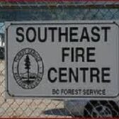
The month of September was the tale of two different weather patterns for the West Kootenay according to Ron Lakeman meteorologist at the Southeast Fire Centre in Castlegar.
The past few weeks is remains the nightmare West Kootenay residents, used to experiencing an Indian Summer, would like to forget.
Lakeman said the last half of September was more typical of cooler autumn than was has been the norm the past few years.
“Numerous Pacific disturbances produced frequent rain and much cooler temperatures,” Lakeman explained.
“More than 80 percent of the months total rain fell during the final 15 days of the month, only three days during this period were rain free.”
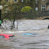
The lowlight was the 21.4 millimeters of rain Mother Nature dumped on the region September 28, which turns out to be a new record for maximum rainfall on the date.
Lakeman said the start for September, other than a system that produced a few thundershowers and relatively cooler temperatures on the 6th and 7th, the month was but a continuation of the glorious summer experienced in much of the region.
“The warmest temperature of the month (32.3 degrees) was recorded during the afternoon of September 2,” Lakeman said.
“Record maximum mean temperatures (warmest average temperatures) were set on the 13th and 14th.”
Lakeman said despite the latter half of September cooling off drastically, the mean temperature averaged out to be 1.8 degrees warmer than normal.
The same held true for the rainfall. Only, the amount of rainfall was simply not a few millimeters more.
“Not surprising was the total monthly rainfall of more than double the normal,” he said.
“With 91.4 millimetres of rain it was the wettest September since 2004 and the third wettest September since local records began in 1966.”
The early forecast for October shows a drying trend with is cooler temperatures.