A foot of new snow in backcountry, but avalanche conditions have tamed

By Nelson Daily Staff
Up to 30 centimetres of new snow has fallen in the West Kootenay backcountry in the last week, producing loose snow and storm snow instabilities, as well as the odd wind slab in exposed terrain, for skiers heading out on the May long weekend.
Reports of snow cover decreasing by as much as 100 cm. indicate spring conditions are becoming established, said the Canadian Avalanche Centre’s Karl Klassen, especially at low to mid elevations.
“I’d guess deep snowpacks are well bonded and the only significant weaknesses remaining are at the very bottom, near the surface when the snow is in the melt phase of the melt freeze cycle, or when the snow is isothermal,” he said in the CAC’s now weekly report.
“I think the deep instabilities we saw last week are not going to be as big an issue this weekend, but certainly deep slab releases remain possible where no recent avalanches have occurred in shallow snowpacks on steep, unsupported, slopes.”
Friday, Saturday and Sunday look mostly sunny and warm with freezing levels reaching the 3,000-metre mark in eastern and southern regions, perhaps a little cooler in the north and west.
A southerly flow returns as the weekend progresses and by late Sunday and Monday it brings more unsettled weather with light precipitation and seasonal temperatures, but freezing levels are suppressed where cloud cover blocks the sun.
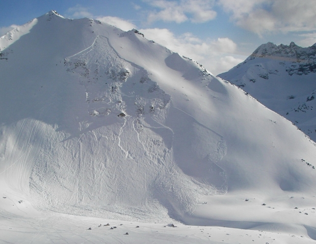
After last week’s excitement, avalanche activity has slowed in recent days as temperatures fell and cloudy skies limited solar radiation. That said avalanches, including some big deep ones, were still occurring last weekend and into this week, Klassen said.
“For the most part, this recent avalanche activity has been more what you’d expect in mid-May: wet, loose slides on steep sunny slopes, some slabs in the upper layers of the snowpack, and occasional cornice falls, which sometimes trigger avalanches on slopes below,” he said.
Activity has been mostly temperature and solar radiation triggered although a few human triggered slides were reported, especially where new snow and wind early in the week created loose snow or slab instabilities on crusts.
Avalanche danger this weekend will almost certainly be closely related to air temperature and solar radiation. Danger is generally lower when and where temperatures are cool, sun is not affecting slopes or cornices above, and strong supportive melt-freeze crusts exist.