Avalanche danger ramps up in the West Kootenay region as spring settles in

By Timothy Schafer
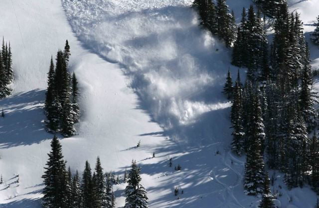
The house is a rockin’ in the West Kootenay backcountry as numerous size three avalanches up to 300 metres wide were observed in the last few days, the Canadian Avalanche Centre says.
Triggered naturally by the sun, warm temperatures and cornice fall, the CAC’s Karl Klassen said.
Avalanche activity has been mostly on sunny, steep, alpine and tree line slopes, but at least one large cornice triggered slide was noted on a shaded slope, he said.
The biggest events are associated with no overnight freeze. Large slides are occurring even in the absence of strong solar radiation.
“This suggests the interior mountains are in the early stages of the first big spring avalanche cycle of the year,” he said. “This activity may slow but will likely continue through the weekend.”
Avalanche danger is closely related to air temperature and solar radiation. Danger is generally lower when and where temperatures are cool, said Klassen in his report, sun is not affecting slopes or cornices above, and strong supportive melt-freeze crusts exist (earlier in the day).
Klassen said to be vigilant and keep an eye on what’s going on above and around you at all times if you venture into the backcountry. Conditions above may be much warmer and unstable than on cold, shaded, slopes below.
Snow conditions are finally catching up to the calendar. On sunny aspects the snow pack is settling into a more uniform mass, said Klassen, although it’s certainly not yet normal for mid-May.
On shaded aspects the surface is likely moist and well settled except on the highest and most northerly slopes where some dry snow may still exist.
Below tree line, due to the recent warm weather and no overnight freeze, the snow pack is largely isothermal, slushy, and unsupportive. At tree line, expect a mix of alpine and below-tree line conditions, depending on aspect and elevation.
“Little change is expected until we see colder overnight temperatures or clear overnight skies, which allow the snow pack to freeze up overnight,” Klassen said.
Always use travel techniques that minimize risk
- Travel across or down avalanche paths one at a time.
- Spread out when crossing runout zones and don’t stop or regroup here.
- Regroup in dense timber or on high ground.
- Travel on ridges whenever possible, but give cornices a wide berth.
- A probe, shovel, transceiver are essential when traveling through or under avalanche terrain.
- An air bag can reduce the consequences if caught.
- Due to exceptional amounts of snow still in the mountains, this equipment remains necessary even though it’s mid-May.
- Obtain rescue training before heading out and practice rescue techniques regularly.
- If you are buried in an avalanche, you will likely not survive if your companions are not able to quickly find you and dig you out.
This information describes conditions likely to exist for the weekend of May 14-15 and provides general advice for managing risk in these circumstances.
The next scheduled update is Thursday, May 19. Current or recent information may also be found in online forums or the ACMG Mountain Conditions Report. Also, check out our spring ski-traverse page.
twitter.com/#!/TheNelsonDaily