UPDATED: Special Weather Statement cancelled

By Nelson Daily Staff
Thanks to the system moving through south of the 49th parallel, the Special Weather Statement for the West Kootenay has been cancelled by Environment Canada.
There will still be periods of rain, with snow level at 1000 metres.
Tuesday, increasing temperature has snow level rising from 1000 to 2000 metres near noon with the amount of precipitation between 15 to 25 mm.
Special Weather Statement issued by Environment Canada
Environment Canada has issued a Special Weather Statement for the West Kootenay as a series of Pacific low pressure systems approach the province and region Tuesday through Wednesday.
“This next Pacific frontal system will move into the British Columbia Interior on Tuesday bringing significant amounts of rain to the aforementioned regions,” the Special Weather Statement said.
“The rain will begin Tuesday morning and will continue through Wednesday. This system could bring rainfall amounts up to 40 mm.”
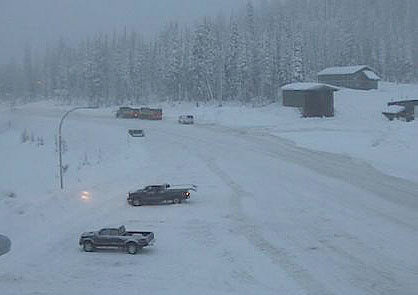
The Special Weather Statement prompted Marc Dale of Yellowhead Road & Bridge Ltd to send out a media release cautioning drivers heading over highway passes during the next few days.
Drivers over Kootenay and Columbia high elevation passes are expected to experience a transition from snow to rain as freezing levels rise Tuesday.
“We are forecasted to receive a significant amount of rain (30-40 mm) over the next 24 hours at all elevations,” said Marc Dale, Operations Manager for SE Kootenay YRB.
“Temperatures are forecasted to stay above freezing overnight in the valley’s and hover around zero as high as the summit on Kootenay Pass.”
Dale said due to the sudden warming trend and heavy rainfall forecast, all traveler’s going over Kootenay Pass will experience a transition from roads being bare and wet to slushy sections and at higher elevation compact snow.
“YRB has graders and plows working on Kootenay Pass 24 hours a day however expect ponding water, winter driving conditions, reduced visibility due to fog as well as heavy rain / wet snow at higher elevations,” he said.
The rain will taper off late Wednesday as the system moves into Alberta.
The public is advised to monitor Drive BC for future forecasts and warnings as warnings may be required or extended.
Story originated at The Nelson Daily