Southeast Fire Centre updates fire situation in region

By Lone Sheep Publishing
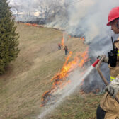
Southeast Fire Centre said Monday that crews continue to several fires in the area this week.
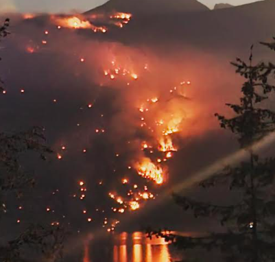
In a media release, the Southeast Fire Centre said that Saturday morning, a blanket of thick smoke settled over most of the fire centre.
“While local fires are contributing, the majority of the smoke is coming from large fires that are burning in western Washington, Oregon, and the south coast of British Columbia,” the Southeast Fire Centre said.
“Atmospheric conditions continue to be conducive to the smoke staying in the region through to Tuesday. Actual smoke levels will depend not only on atmospheric conditions, but also on smoke output from the fires south of the border which can be difficult to predict.”
The Southeast Fire Centre said that the current heavy smoke is keeping fire behaviour low on fires within the region, in some cases, this is allowing ground personnel to get further ahead on direct attack strategies. However, this increased smoke also means that aircraft operations are greatly limited, and in many cases, cannot be carried out safely.
“Airtankers are unable to fly in this type of visibility and helicopter bucketing operations become even more high risk,” Southeast Fire Centre said.
“Helicopters are now only able to fly in limited capacity to perform reconnaissance flights and bucketing operations as pockets of visibility allow.”
Here’s an update on the wildfires in the area:
Fry Creek Wildfire
This fire is located approximately 15 kilometres north of Kaslo on the east side of Kootenay Lake. An incident management team has been brought in to manage this wildfire and has officially taken command as of September 11th. A break in visibility allowed BCWS staff to fly more of the fire. From this flight, the size is now estimated to be 900 hectares. There are still areas of the fire that are obscured by smoke, once it clears and accurate mapping can occur, the size is expected to change.
An evacuation alert remains in place in the vicinity of this fire. For specific information about this alert, please visit: rdck.ca.
An area restriction is in place in the vicinity of the Fry Creek wildfire. For more information and a detailed map of the affected areas, review the information bulletin.
This wildfire is classified as a wildfire of note. For more information and daily updates, visit the Wildfire of Note page.
Monument Creek Wildfire
This fire is located approximately 17 kilometres north of the City of Nelson. Crews are establishing containment lines on the south flank from Duhamel Creek, tying them into rockier areas that can act as natural fuel breaks to prevent down valley growth. Heavy equipment continues establishing containment lines on the east flank above 6-mile lake by re-opening existing road networks. Four helicopters remain assigned to this incident and will perform bucketing operations when visibility allows.
This fire is now estimated to be 660 hectares in size. While fire growth has been minimal since the smoke settled into the area, the size has been updated to reflect estimated growth over the past four days, an updated perimeter track is not available until a response officer can fly the fire in its entirety. Structures are not currently threatened.
Woden Creek Wildfire
This fire is located approximately 27 kilometres northwest of the Village of Slocan and seven kilometres southeast of the community of Burton. It is currently estimated at 145 hectares in size.
Firefighters are continuing to work on containment lines in the northwest corner of the fire. Heavy equipment remains on scene today tying in control lines together. While helicopters were able to perform bucketing operations yesterday (September 11th), current visibility is preventing safe flying operations in this area. Rotary wing resources are available to this fire should visibility improve. Structures are not currently threatened.
The Southeast Fire Centre extends from the U.S. border in the south to Mica Dam in the north, and from the Okanagan Highlands and Monashee Mountains in the west, to the B.C.-Alberta border in the east.
To report a wildfire, unattended campfire or open burning violation, call 1 800 663-5555 toll- free or *5555 on a cellphone.
For the latest information on current wildfire activity, burning restrictions, road closures and air quality advisories, go to: www.bcwildfire.ca or download the BC Wildfire Service public mobile app.