Southeast Fire Centre experiences 85 new wildfire starts since Saturday

By Contributor
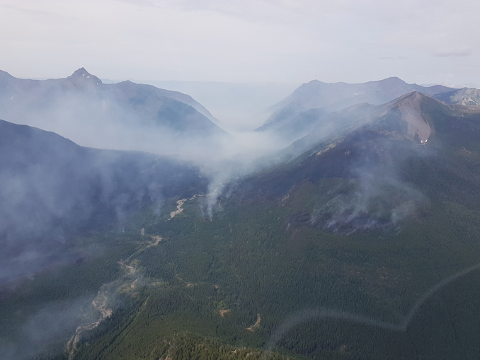
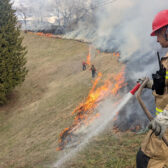
The Southeast Fire Centre continues to be in the crosshairs of Mother Nature as the region experienced 85 new wildfire starts since Saturday (August 11, 2018) a media release Tuesday said — with 16 of which are in the Invermere Fire Zone and Cranbrook Fire Zone.
The BC Wildfire Service is prioritizing these new fires and responding to them accordingly.
There are currently six Wildfires of Note burning within these two zones:
Cross River wildfire
- The Cross River wildfire is about nine kilometres east of Highway 93 and about 23 kilometres northeast of the Village of Radium. It covers about 2,723 hectares.
- Fifteen personnel are on site, supported by four pieces of heavy equipment.
- The Regional District of East Kootenay has implemented an evacuation order for the Cross River/Nipika Mountain Resort areas. For more information about this order, please call the Regional District of East Kootenay at 250 426-2188, or visit its website:
Leach Creek wildfire
- The Leach Creek wildfire is about three kilometres north of Mount Taylor and 21 kilometres southeast of Sparwood. It covers about 30 hectares.
- This fire is 95% machine-guarded and is “being held”. Nine personnel are on site.
- The Regional District of East Kootenay has issued an evacuation alert for the community of Corbin and a portion of Corbin Road in Electoral Area A. A map of the evacuation alert area is available on the Regional District of East Kootenay’s website
- The District of Sparwood has issued an evacuation alert related to the same fire. The district’s alert area covers the portion of Corbin Road that lies within municipal boundaries and the Coal Mountain Mine property. For more information about this evacuation alert, please visit the District of Sparwood’s website:
Meachen Creek wildfire
- The Meachen Creek wildfire is in Kianuko Provincial Park and the Meachen Creek drainage, about 10 kilometres southwest of St. Mary Lake.
- This fire currently covers about 10,000 hectares and this figure may change at a later date with increased mapping accuracy.
- The fire is being closely monitored and is currently burning toward the northeast, down the Meachen Creek drainage. There has been minimal spread of the fire over the past few days, due to cooler conditions and lighter winds.
- The safety of St. Mary Valley residents remains the top priority for the BC Wildfire Service and it is developing containment strategies should the fire continue burning down the Meachen Creek drainage and into terrain where it will be safer for fire crews to work on it.
- An evacuation alert has been issued by the Regional District of East Kootenay in the St. Mary Lake area, from the western boundary of the City of Kimberley to the Redding Creek/St. Mary’s River convergence, including St. Mary Lake Road and Lakefront Road. For more information about this evacuation alert, please call the Regional District of East Kootenay at 250 426-2188 or visit its website:
Lost Dog Complex
- The Lost Dog Complex is about 14 kilometres north of Kimberley. It is a cluster of three wildfires and their current combined size is about 452.5 hectares.
- There are 42 personnel on site, supported by two helicopters and six pieces of heavy equipment.
- An evacuation alert has been issued by the Regional District of East Kootenay in the Ta Ta Creek area, including an area west of the Kootenay River, from 1.5 kilometres south of Farstad Way Road to 2.5 kilometres north of Woods Corner. For more information about this evacuation alert, please call the Regional District of East Kootenay at 250 426-2188 or visit its website:
Coal Creek Forest Service Road wildfire
- The Coal Creek Forest Service Road wildfire is about 12 kilometres east of Fernie and covers about 713 hectares.
- There are 11 personnel on site, assisted by air support and five pieces of heavy equipment.
- This fire is not currently threatening structures or communities, but it is highly visible from Fernie and Alberta.
Sage Creek wildfire
- The Sage Creek wildfire is about 65 kilometres southeast of Fernie and about six kilometres southwest of the B.C.-Alberta border.
- This fire currently covers about 1,936 hectares.
- There are 102 personnel on site, supported by 12 helicopters, two airtankers and one piece of heavy equipment.
To report a wildfire or open burning violation, call 1 800 663-5555 toll-free or *5555 on a cellphone. For the latest information on current wildfire activity, burning restrictions, road closures and air quality advisories, visit BC Wildfire website.
You can also follow the latest wildfire news on:
- Twitter:http://twitter.com/BCGovFireInfo
- Facebook:http://facebook.com/BCForestFireInfo