New snow could spell trouble in West Kootenay backcountry

By Nelson Daily Staff
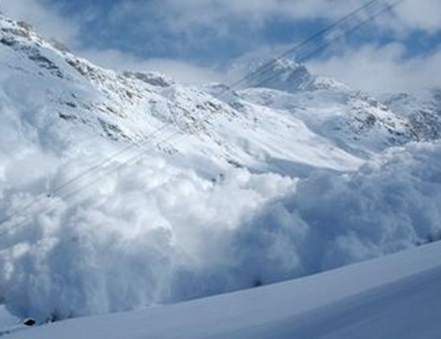
The risk of avalanche at alpine in the West Kootenay backcountry will rise to considerable on Wednesday and Thursday as forecasted new snow is expected to fall on a very weak surface, according to the Canadian Avalanche Centre.
“Several persistent weaknesses are being tracked by the professional crowd,” said CAC’s James Floyer. “Triggering one of these deeper weaknesses could yield a large avalanche.”
That means “touchy” wind slabs will likely develop in exposed lee areas, he added in his avalanche report for this week (http://www.avalanche.ca/cac).
Although forecast winds at the tree line elevations are presently light, if the wind blows harder than expected, or new snow amounts come in higher than forecast, bump up the danger ratings by one for the tree line.
There was a rider-triggered avalanche on Saturday on Mt. Plewman near Rossland.
Tuesday: Flurries during the day, light snow starting late in the day. Moderate westerly winds.
Wednesday: Snow amounts of 10-15 centimetres, freezing levels staying at valley bottom. Light westerly winds.
Thursday: A further 10 cm. or so of snow. Freezing levels rising to around 1,000 metres. Moderate to strong westerly winds.
Terrain to watch
• Wind-loaded slopes around ridgelines, the tops of bowls and on convex rolls in exposed terrain
• Steep, alpine terrain where the lower crust exists, especially in thinner snowpack areas.
• Terrain traps that increase the consequence of a small avalanche
Travel advice
• Look for signs of wind slab, such as drifting snow, cracking of the upper snowpack as you ride over it or denser snow under your sled or skis. If you see these signs, back off onto shallower terrain.
• Try to anticipate where thin spots on the slope may be. The crest of convex rolls are a good bet, as are slopes where you can see rocky outcrops. Stay well away from these thin spot
• As always, group up well away from avalanche terrain, even if it obscures your view of other riders a little. One at a time on the slope.
Snowpack
The alpine has been hammered by the wind and highly variable wind-affected surfaces now exist. A surface hoar layer lies buried under around 25 cm. of snow in more sheltered locations at tree line.
A rain crust lies 30-40 cm. below the surface and was reported from Kootenay Pass and the Rossland area. Around 90 cm. of snow now sits on the (Dec-08) surface hoar/crust interface; this interface appears to have bonded.
Snow depths are variable but average around 150 cm. at tree line.