UPDATED: Hazardous winter conditions expected Tuesday

By Nelson Daily Staff
Environment Canada has advising the public that hazardous winter conditions are expected, with heavy snow expected Tuesday through Tuesday night.
"An approaching moisture-laden warm front will bring heavy snow to the Boundary, West Kootenay and Elk Valley regions on Tuesday," the Environment Canada Winter Storm Warning statement said.
"The snow will start falling shortly after midnight and then become heavy at times beginning early morning. The heavy snowfall will taper off after midnight on Wednesday."
Boundary: Greatest accumulations expected along Highway 3 and for the City of Grand Forks where up to 25 cm can be expected by Wednesday morning.
West Kootenay: Greatest accumulations expected in southern regions such as the City of Trail where up to 40 cm can be expected by Wednesday morning. 15 to 25 cm can be expected for Castlegar.
Kootenay Pass: Snowfall amount near 35 cm can be expected by Wednesday morning.
Elk Valley: Greatest accumulation expected for the City of Fernie and along Highway 3 south to Elko where up to 25 cm of snowfall can be expected by Wednesday morning. 10 to 15 cm of snow can be expected for Sparwood.
Visibility may be suddenly reduced at times in heavy snow.
Please continue to monitor alerts and forecasts issued by Environment Canada. To report severe weather, send an email to ec.tempetepacifique-pacificstorm.ec@canada.ca or tweet reports using #BCStorm.
Environment Canada calls for major snow storm Tuesday, colder after Thursday
Do not put away the snow shovels just yet.
Environment Canada has issued a Special Weather Statement Monday for most of the Southern Interior, including the Boundary, West Kootenay as weather will become very wintery-like across this week.
"Tuesday a deepening Pacific low pressure system will track up and across northern Washington state," Environment Canada said.
"This system will combine plentiful moisture with cool northerly winds near the surface. The result will be heavy snow starting tonight and continuing through Wednesday morning for most communities in the southwestern Interior and Kootenays."
Environment Canada said storm total snowfall amounts will range from 15 to 25 cm with the highest amounts falling near the U.S. border.
"Some regions in the Kootenays may get more than 25 cm from this storm with Winter Storm Watches are in effect for Boundary, West Kootenay and Elk Valley," Environment Canada said.
"A break in the weather is forecast later Wednesday before an Arctic front sweeps through on Thursday. The Arctic front will bring a few flurries and, more noticeably, colder air to the southern interior for the rest of the week. Overnight lows will drop to between minus 10 and minus 15; daytime maximums will be several degrees below zero."
Cold air is expected through the end of the week, with temperatures on Saturday dropping to minus 6 (minus 8 Sunday) in the interior during the day and minus 10 and minus 12 Friday and Saturday night.
ShiftIntoWinter.ca reminds drivers to know before you go. Adjust to winter driving behaviour and use winter tires and chains.
Road conditions are available at DriveBC.
Snowfall Warning issued for West Kootenay, Boundary highways
Environment Canada has issued a snowfall warning for the Paulson Summit to Kootenay Pass as between 15-25 cm are expected to fall into Sunday night.
Environment Canada said a Pacific front moving across the BC Interior is spreading snow to the region today and tonight.
(Sunday) is the heaviest snow is expected across the North and West Columbia, Kinbasket and North Thompson regions," Environment Canada said. "As the front continues to move southward the heaviest snow will shift to Arrow Lakes – Slocan Lake, Kootenay Lake and Kootenay Pass tonight."
Snow is expected to taper off Monday as the front exits the province.
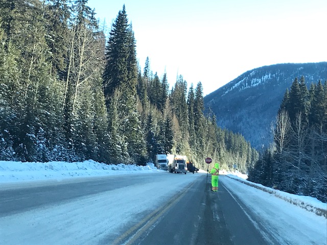
However, rapidly accumulating snow could make travel difficult over some locations and visibility may be suddenly reduced at times in heavy snow.
Marc Dale of Yellowhead Road & Bridge said the weather pattern is expected to make driving challenging through to mid-week.
"We are experiencing a change in our forecast today that includes rain, freezing rain, heavy wet snow and warming temperatures," Dale said.
"This unsettled weather system will begin this afternoon and continue until mid-week. Accumulations of snow in the valleys will vary from 5 to 10 cm with amounts increasing substantially at higher elevations."
Dale said plow trucks are out salting and sanding in advance of this winter system moving in to our area and motorists should be prepared for winter driving conditions beginning tonight and continuing over the next couple days.
"Travelers will experience reduced visibility, changing road conditions and blowing snow," he said.
"Motorists, please allow extra time to reach your destination, watch for flashing amber lights and give snow plows plenty of space to complete their work."
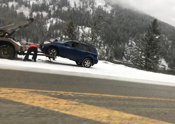
This is the second storm in a few days. Friday, in Nelson, the streets were filled with accidents as drivers took a slower time to acclimatize to winter driving.
ShiftIntoWinter.ca reminds drivers to know before you go. Adjust to winter driving behaviour and use winter tires and chains.
Road conditions are available at DriveBC.
YRB 24 hour answering service is available at 1-888-352-0356 and they will communicate your concerns to our staff when contacted.