Sudden fire activity at Harrop Creek Wildfire prompts RDCK to issue Evacuation Alert

By Nelson Daily Staff
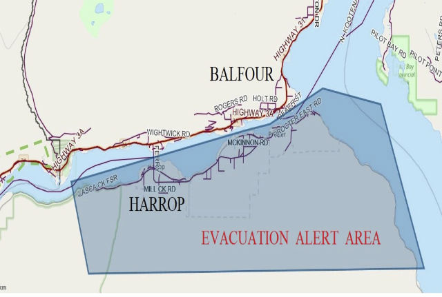
A shift in fire activity of the Harrop Creek wildfire has prompted the Regional District of Central Kootenay Emergency Operations Centre to place 486 properties in the area of Harrop, Procter, Sunshine Bay and Kootenay Lake Village on Evacuation Alert a media release said Thursday afternoon.
“This Evacuation Alert has been issued to prepare residents to leave at a moment’s notice should the fire threaten lives or properties,” the RDCK release said.
“Athough there is no requirement for residents and visitors to leave at this time, it is recommended that preparations should be made including the relocation of livestock, trailers, and boats.”
The BC Wildfire Service said winds overnight increased fire behavior on the east flank.
“This fire has now entered the Narrow Creek Drainage,” BC Wildfire Service said.
“Personnel are reassessing this fire and working on contingency plans.”
The BC Wildfire Service added the 2,532-hectare wildfire is in difficult terrain containing volatile fuel types that challenge fire suppression operations.
“There is no updated fire size available at this time,” the BC Wildfire Service said.
“With increased wind activity expected in the Southeast Fire Centre, paired with the hot and dry conditions continuing in the region, the BC Wildfire Service is anticipating an increase in fire behaviour heading into the long weekend.”
The RDCK release said this action can only take place within the Evacuation Alert phase as there is only one access/egress route that depends on the cable ferry.
“In the event of an Evacuation Order, the ferry would be restricted to vehicles and passengers only, due to limited time and ferry capacity. Absolutely no trailers will be allowed,” the RDCK said.
The release said all RDCK residents, businesses and visitors are encouraged to sign up to the RDCK Emergency Alert system which will contact users when an emergency or disaster strikes in their area and action is required.
To sign up, go to the RDCK.
For updates on the current Harrop Creek wildfire situation, visit the RDCK website
In other fire Southeast Fire Centre news:
Forest Service Road Closure
- The Lodgepole FSR wildfire (N11971) is located approximately 33 kilometres southeast of Fernie. This fire is currently not threatening any structures or communities, however, it will be impacting the Lodgepole Forest Service Road, which is one of the main road systems providing access to and from the Flathead geographic.
- This fire is estimated to be 600 hectares in size.
- In the interest of public safety, a road closure in effect for the Lodgepole Forest Service Road starting at the 35-kilometre mark through to the 42-kilometre mark.
- A detailed map of the road closure can be found here: http://ow.ly/e5Ut30ePzSt
Update on Off Road Vehicle Restriction
- The prohibition specific to off-road vehicles does not apply to private land. The ORV prohibition does not apply to agriculture, emergency responders or commercial/industrial users who operate ORVs for farming, emergency response or business purposes. The ORV prohibition also does not apply to individuals who are customers of and remain in the presence of a commercial/industrial user operating an ORV for business purposes.
- The prohibition specific to on-highway vehicles, as identified in the off road vehicle regulation, section 2(e), does not apply when travelling on a road as defined in the forest planning and practices regulation.
- The prohibition specific to motorcycles, as identified in the off road vehicle regulation, section 2(b), does not apply to motorcycles that are licensed for operation in accordance with the Motor Vehicle Act, when travelling on a road as defined in the forest planning and practices regulation.
- This order remains in force until the earlier of 12 noon (Pacific time) on Oct. 31, 2017 or until the order is rescinded.
The Southeast Fire Centre extends from the U.S. border in the south to the Mica Dam in the north and from the Okanagan Highlands and Monashee Mountains in the west to the B.C.-Alberta border in the east. The Southeast Fire Centre includes the Selkirk Natural Resource District and the Rocky Mountain Natural Resource District.