RDCK pitches in to complete the Trans Canada Trail

By Suzy Hamilton
If all goes well, a 25 year dream will be completed in 2017, just in time for Canada’s 150th birthday party, when the East and West Kootenays are linked to the Trans Canada Trail (TCT).
To date, nearly 17,000 kilometres of the trail—hailed as the longest recreational trail in the world— are operational, which is 75 percent of the proposed route. Four out of five Canadians live within 30 minutes of the Trail.
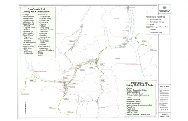
The Kootenays have been identified as weak link in the trail from Castlegar to the Alberta border, so RDCK staff presented a map of the trail through communities and the RDCK areas at the January 15 meeting of the board, and recommended that board members continue to work with local stewardship groups to ensure completion for the birthday party.
The Trans Canada Trail committee even hired a consultant in Castlegar to help specifically with the route completion in the Kootenays.
“This came up a few years ago, but nothing happened,” said Area A director (East Shore) Garry Jackman. “Now with the push on maybe federal funds will be available. I have a feeling we’ll be the last spike.”
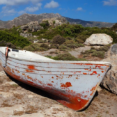
Jackman’s portion of the route takes hikers and bikers over the 80 km Gray Creek Pass forest service road that links the East and West Kootenays from Crawford Bay to Kimberley.
And although completing this leg is not for the faint hearted or the unprepared, Jackman is more worried about the passage along the winding, narrow section of the East Shore highway near Gray Creek.
“We need to sit down as a community and get off the highway,” he said, adding that an alternate route may be along the power line for a stretch, since widening the road would be too costly.
Cyclists will then continue to the Kootenay Bay Ferry on Hwy 3 A to Balfour, ride the highway to Nelson and pick up the Great Northern Trail, riding through Lakeside Park, up city streets to access the GNR Trail.
A bridge over Rover Creek west of Nelson has been proposed to enable the route to Castlegar. A log is now the only transport across the creek for cyclists and hikers to access the Morning Mountain trails.
Area I director Andy Davidoff (Shoreacres to Pass Creek) has partnered with Area E Director Ramona Faust (Procter to Blewett) to help leverage funds for the bridge, still in the planning stages.
With the help of the Castlegar Friends of Parks and Trails, the directors are hopeful the bridge will be completed.
“I’d like to work with stewardship groups and the RDCK to leverage funds to bring the TCT into our area,” said Faust after the meeting.
Equally optimistic, Davidoff adds,” It’s looking pretty good to get the trail finished in time.”
But Al Skucas, director of the Rockies and Kootenay portions of Trails BC said the Kootenays have the least amount of trails in BC. Of the 550 km route, less than 100 km of trail have been completed.
He said this is because communities are far apart. This is a project “linking Canadians by linking communities,” he said. Some of the routes may have to be designed “blue routes,” which are water routes connecting the trails.
In his area, he was instrumental in completing the North Star Trail, a 25 km paved trail from Cranbook to Kimberley, which he termed “a rustic compliment” to the TCT.
The TCT also nicely compliments an Active Transportation Plan released by the city of Nelson in 2010.
Gas may be cheaper now, but feet and bike power are free, healthy, carbon-free and used widely in Nelson.
The report identified that more than one third of Nelson residents bike or walk to work, as compared to an average of nine percent of the rest of BC residents who use “active transportation”.
And this is in spite of steep hills, icy paths and an aging population, said the report.
The report noted that some of the areas of concern in Nelson for the TCT are narrow roadways, access to Great Northern Rail Trail is steep, transit service is infrequent and sidewalks are not treated as a high priority for plowing.
The TCT was specifically addressed in the report and criteria such as minimizing the grade, providing a map that used existing infrastructure, supplying exposure to downtown amenities and offering a shuttle to Mountain Station from downtown were suggested.
The board passed staff’s recommendation at the January meeting. “It’s got to happen,” said Jackman. ‘There’s a lot of enthusiasm and I’m happy we’re going to see it move forward.”
Other communities that will benefit are Salmo, the Slocan Valley and Slocan city as rail trails are already linking these communities to the TCT.