More snow in forecast for West Kootenay, Boundary

By Nelson Daily Staff
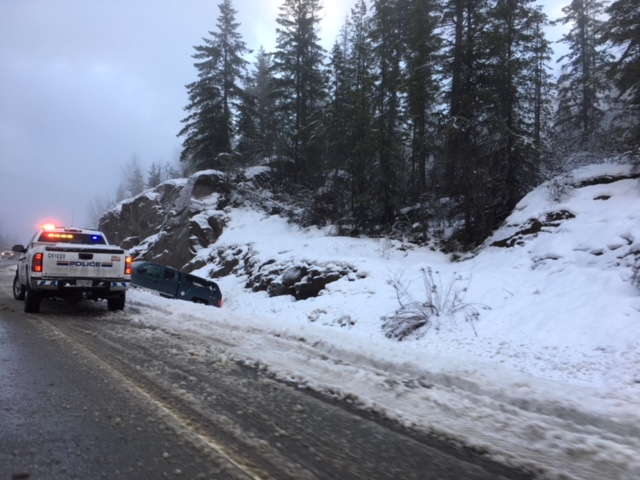
Anyone planning to drive in the Southern Interior of BC should be prepared to take it slow after Environment Canada continued its Snowfall Warning Sunday.
Environment Canada said a long period of snowfall, with total amounts of 20 to 30 cm is expected as a moist frontal system will move across BC interior today into Monday, producing heavy snowfall over several highway passes — including Highway 3, Paulson Summit to Kootenay Pass.
“The southwesterly flow is favourable for generating heavy snow over Coquihalla summit and Allison Pass, where 30 to 50 cm of snow is possible by the end of tonight,” Environment Canada said.
“There is also a risk of freezing rain over this route tonight.”
Environment Canada said heavy snow will spread into Rogers Pass by tonight, where snow accumulations of 20 to 35 cm are possible by Monday afternoon.
“Though periods of snow will start over Kootenay Pass (Sunday), the most substantial snowfall is expected to occur on Monday (with) a total snowfall amount of 25 to 35 cm is possible by Monday afternoon,” Environment Canada said.
“Visibility may be suddenly reduced at times in heavy snow. Poor weather conditions may contribute to transportation delays.”
“Weather in the mountains can change suddenly resulting in hazardous driving conditions,” Environment Canada added.
There were numerous fender bender accidents in and around the region, including several in Nelson as crews attempted to keep up with the snowfall.
ShiftIntoWinter.ca reminds drivers to know before you go. Adjust to winter driving behaviour and use winter tires and chains.
Road conditions are available at DriveBC.