McArthur Creek fire burning 10 km east of Shambhala Music Festival

By Nelson Daily Staff
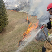
The BC Wildfire Service is currently responding to three new wildfires that may interest the public in the Southeast Fire Centre — of importance to festivial goers, McArthur Creek fire near the Shambhala Music Festival.
However, in a media release Thursday, the Southeast Fire Centre said no evacuation alert is anticipated at this time.
“An evacuation alert has not been issued for the Shambhala Music Festival,” the media release said. “With a favourable wind direction in the forecast, no evacuation alert is anticipated for the music festival at this time.
Currently there are 279 fires in the Southeast Fire Centre, with a total of 4,189 hectares burned.
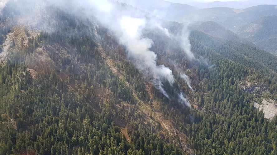
The Southeast Fire Centre said lightning caused McArthur Creek wildfire is in the Mount Waldie area, about 13 kilometres southeast of Salmo, about nine kilometres east of Highway 6 and about 10 kilometres east of the site of the Shambhala Music Festival. This fire, currently covering about 56 hectares as of Friday around noon, is burning in remote terrain and is being closely monitored by the BC Wildfire Service.
“The fire is surrounded by favourable geographic features that could act as fuel breaks,” the Southeast Fire Centre said.
In 2017, the McCormick Creek wildfire 20 kilometers southwest of Salmo forced Regional District of Central Kootenay officials to issue an evacuation alert to festival participants. However, cooler weather arrived just in time to slow the growth of the wildfire and allow the music festival to continue.
The release said in the interest of public safety, the Regional District of Central Kootenay has issued an evacuation alert for the McArthur Creek area, southeast of Salmo. More information about this evacuation alert is available by calling the Regional District of Central Kootenay at 250 352-7701, or visiting its website: www.rdck.ca
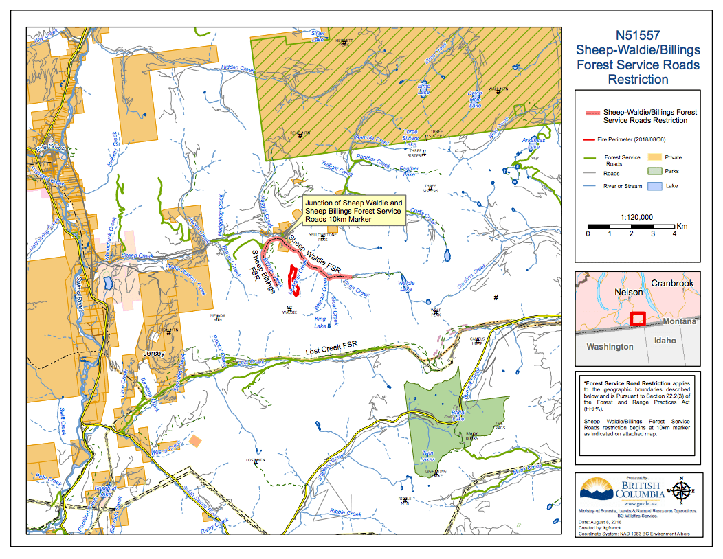
The Southeast Fire Centre said effective immediately, the Sheep Waldie Forest Service Road and the Sheep Billings Forest Service Road are closed (see map below), starting at the 10-kilometre mark on the Sheep Creek Forest Service Road, at the junction of Sheep Waldie and Sheep Billings Forest Service Road.
No public access is permitted on these sections of road. A detailed map of the road closure is available online: http://ow.ly/t6mG30lkeUi
Other Wildfires Include:
Blazed Creek wildfire:
- The Blazed Creek fire is about 26 kilometres northwest of Creston and two kilometres north of Highway 3.
- This fire currently covers about 80 hectares and is highly visible from Highway 3, but it is not currently impacting the highway.
- Twenty-one firefighting personnel are on site today, assisted by three helicopters and four pieces of heavy equipment.
Cross River wildfire:
- The Cross River wildfire is about 23 kilometres northeast of the Village of Radium and about nine kilometres east of Highway 93.
- This fire currently covers about 36 hectares and is being closely monitored by the BC Wildfire Service.
- In the interest of public safety, the Regional District of East Kootenay has issued an evacuation alert for the Cross River/Nipika Mountain Resort areas. More information about this evacuation alert is available by calling the Regional District of East Kootenay at 250 426-2188, or by visiting its website: www.rdek.bc.ca
- Effective immediately, the Cross River Forest Service Road is closed from the 16-kilometre mark, up to the junction with the Cross Mitchell Forest Service Road and the Cross River Forest Service Road. This road closure applies to all non-industrial road traffic. A detailed map of the road closure is available online: http://ow.ly/ir9l30lkeNM
- The BC Wildfire Service is implementing this road closure to minimize non-essential traffic and allow for more effective wildfire response. The public is advised to use extreme caution when travelling on forest service roads near closed roads, since there will be increased activity in these locations. Do not stop on the road or impede traffic in any way. This road will remain closed until the public is otherwise notified.
Akenside Creek wildfire:
The Akenside Creek fire is not a wildfire of note, but smoke from this fire is highly visible in the area.
- The Akenside Creek wildfire is about 26 kilometres northwest of the Village of Radium and 19 kilometres west of Highway 95, and covers about 134 hectares.
- This fire is burning in remote terrain and is not impacting communities or structures.
- On Wednesday, Aug. 8, fire crews completed burn-off operations on this fire, which covered about 100 hectares, and helped contain this wildfire within predetermined boundaries.
- As a result, additional smoke will continue to be visible from Highway 95, Radium and surrounding communities.
The Fire Danger Rating in the Southeast Fire Centre is predominantly "high", with some pockets of "extreme". With increasingly hot and dry conditions and wind in the forecast for the end of this week, it is critical that the public remain vigilant, report wildfires and prevent new fire starts.
There has not been significant lightning activity in the region over the past few days. However, there have been "holdover" fires sparked by lightning strikes that occurred over 10 days ago. These flare-ups can occur after prolonged hot and dry conditions, paired with wind activity. These types of fires tend to burn aggressively once they flare up.
Wind from the southwest continues to push smoke from large fires in the United States into the Southeast. Additional smoke is entering from large fires in the Okanagan, which is mixing with smoke from local fires.
The Southeast Fire Centre extends from the U.S. border in the south to the Mica Dam in the north, and from the Okanagan Highlands and Monashee Mountains in the west to the B.C.-Alberta border in the east. The Southeast Fire Centre includes the Selkirk Natural Resource District and the Rocky Mountain Natural Resource District.
To report a wildfire or open burning violation, call *5555 on a cellphone or 1 800 663-5555 toll-free.
For the latest information on current wildfire activity, burning restrictions, road closures and air quality advisories, visit: bcwildfire.ca