City Hall plaza could undergo changes under draft plan

By Nelson Daily Editor
By Timothy Schafer, The Nelson Daily
A City Hall plaza complete with cafés and other commercial ventures was one of four focal points being proposed in the new draft plan that could revitalize Nelson’s downtown and waterfront.
The civic spaces were highlighted in the release Tuesday of the City’s draft Sustainable Waterfront and Downtown Master Plan, recently completed by Vancouver’s IBI group, and set for an open house March 9 at the Hume Hotel (6-8 p.m.).
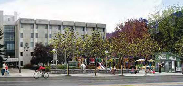
Four focal points, or civic spaces, were intended to be placed in front of important buildings and would be enhanced with public art, cafés and landscaping, including the plaza in front of City Hall.
That plaza “should be activated and enlivened by way of public art and the possible inclusion of commercial to activate the space,” the draft plan read. Currently, the plaza does not generate a significant level of public activity warranted by the importance of the space, the draft plan noted.
“Potential infill at this space, such as a café, would help frame and activate the plaza and enhance the significance of Ward Street,” the draft plan read.
The plaza in front of City Hall is an ideal location and size to become the city’s primary ‘outdoor living room,’ the draft plan read.
In addition to the café, the area could be configured to accommodate a large, continuous area for several hundred people to gather for civic celebrations, one or several small retail or food businesses at its northern edge, interactive public art, interactive fountains, gardens, playground, bocce ball or a small stage area.
Around 152 hectares of downtown and waterfront land were taken into account in the design that is expected to guide the future decisions and vision of City council in its decision making around the lands in question — and will become part of the Official Community Plan once adopted.
As well, a new civic plaza was proposed for the half block of Hall Street on the south side of Baker Street (where the City could locate public restrooms), one for the CP Rail Station and another at the end of Hall Street where it meets the waterfront.
It also suggested mixed-use affordable housing be placed on the Front Street lot near the Nelson and District Community Complex’s aquatic centre.
The lake and the pier were to become the focus of the activity of Hall Street, with infill commercial uses along the eastern edge of the street encouraged in order to “animate the space.”
Bridge over troubled tracks
Downtown and Railtown could become better connected to the waterfront through additional linkages that include potential at-grade or bridge crossings over the CPR tracks, and a trail system following Cottonwood Creek, the draft plan proposed.
Three possible new connections are suggested across the CPR tracks, the most critical between Lakeside Drive and Baker Street’s west end in order to make Lakeside Drive a looped system rather than a dead end.
Additional overhead crossings were proposed at Kootenay and Ward streets.
Park it here
Additional parks were proposed in the draft plan where Hall Street connects to the waterfront trail, west of Cottonwood Creek, in waterfront Central (Kutenai Landing), at Red Sands Beach and in waterfront north (North Shore).
As well, the completion of the waterfront trail was recommended so that it runs continuously from Cottonwood Creek to Red Sands Beach.
The Draft Sustainable Waterfront and Downtown Master Plan [PDF – 10.4 MB] will be presented to the community on March 9 from 6-8 p.m. in the Hume Room of the Hume Hotel. Two presentations will occur throughout the evening (6:15 p.m. and 7:15 p.m.) to highlight key elements of the draft plan.
Trashing transit
Streetcar service was proposed as the viable long-term alternative to bus service, aligning downtown connections to the waterfront.
An extension of the existing streetcar line was suggested west along the waterfront, with the streetcar using the Kootenay Street Bridge, if it was developed, in order to bring the streetcar into the downtown area.
New streets
Five new streets were proposed to better connect the downtown and the waterfront. They include:
• CPR street. A crossing of the CPR tracks in Railtown in order to create a loop street network along the western waterfront, with the road running parallel to Cottonwood Creek.
• Baker Street to Government Road. A new street connecting the two to provide better north-south connectivity.
• Lakeside Drive to Poplar Street. A shoreside extension of Lakeside Drive to connect to Poplar Street to be added when the mall site is re-developed.
• Cedar. Should be extended to connect to Lakeside Drive.
• Sproat Drive and Red Sands Beach. Short connections made to John’s Walk and Nelson Landing to improve traffic flow in both areas.
Home on the waterfront
Around 800 new multi-family housing units could be created in the waterfront neighbourhoods, spawning 200 to 400 new jobs on the waterfront.
Over the next decade, the draft plan predicted there could be as many as 4,500 more people in the Nelson region than there are today. Approximately 61 per cent of those people will be in the working age groups.
Approximately 200 additional multi-family residential homes are proposed to be added to the downtown over time, mostly on sites that are vacant or underutilized.
Species at risk
White sturgeon and Nuttall’s waterweed are located within Kootenay Lake and are considered species at risk. Sturgeon habitat covers the entirety of the lake within the project area, while waterweed is documented within a small zone.
“Proposed development may be possible, however, mitigation could prove difficult,” the draft plan read. “Additional investigations and extraordinary compensation measures may also be required.”
Contamination analysis
There are 20 sites on the waterfront and four sites downtown identified in the Ministry of Environment’s registry as schedule two sites (brownfield).
The sites will need remediation — the cost of which could be considerable — and will be assessed on a site-by-site basis.
There are three phases recommended:
Phase one
• downtown infill and intensification, especially mixed use projects providing housing;
• Downtown plaza development, especially at Hall Street;
• Hall Street improvements and Cottonwood Creek revitalization, conecting the downtown and Kootenay Lake;
• Waterfront Cnetral residential development, especially on Kutenai Landing site and Yellowhead Road and Bridge yard sites;
• Intensificiatrion of light industrial uses within Railtwn;
• Intensification adjacent to the CP Station building in Railtown; and
• Intensification of the Waterfront East district, including the associated waterfront trail and park at Red Sands Beach.
Phase two
• Creation of an additional physical conection between downtown and the waterfront West district, ideally the at-grade crossing near the western end of Baker Street;
• Redevelopment of the Chahko Mika Mall site and relocation of the regional retail uses to Waterfront West;
• Intensificiation of residential and mixed uses within Railtown towards Cottonwood Creek Falls Park; and
• Intensificisation of light industrial uses within the Waterfront West district.
Phase three
• Intensificiation of the CP Rail yards with light industrial and commercial uses; and
• Creation of a new waterfront trail and Park on the North Shore.
editor@thenelsondaily.com