Area restrictions, road closures in the Southeast Fire Centre

By Contributor
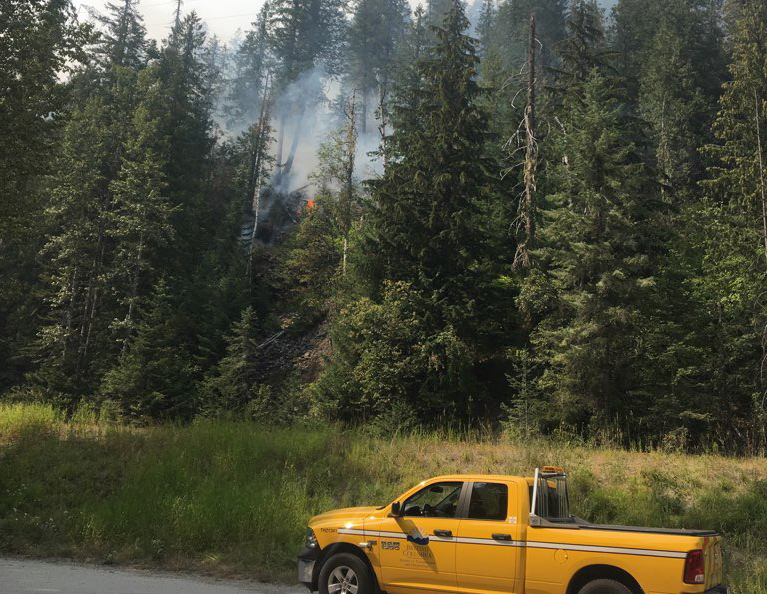
There are currently several road closures and area restrictions in effect within the Southeast Fire Centre to help ensure the safety of the public and firefighting personnel and to avoid interference with fire-control activities, including Highway 3 Kootenay Pass.
The Highway was forced to shutdown due to an increase in smoke and rolling debris from this fire tonight. In the interest of public safety, Highway 3 is now closed in both directions.
Other public access to these areas or sections of road is not allowed. These restrictions and closures will remain in effect until the public is otherwise notified.
Boundary Fire Zone, Arrow Fire Zone and Kootenay Lake Fire Zone:
- An area restriction is in effect for the Randal Creek wildfire, from the six-kilometre mark of the Yahk Meadow Creek Road up to the 12-kilometre mark of the Hawkins Creek Main Line. A detailed map of this area restriction is available online .
- An area restriction is in effect for the Blacktail Mountain wildfire that includes the entire Silverton Creek drainage, including Idaho Peak. A detailed map of this area restriction is available online .
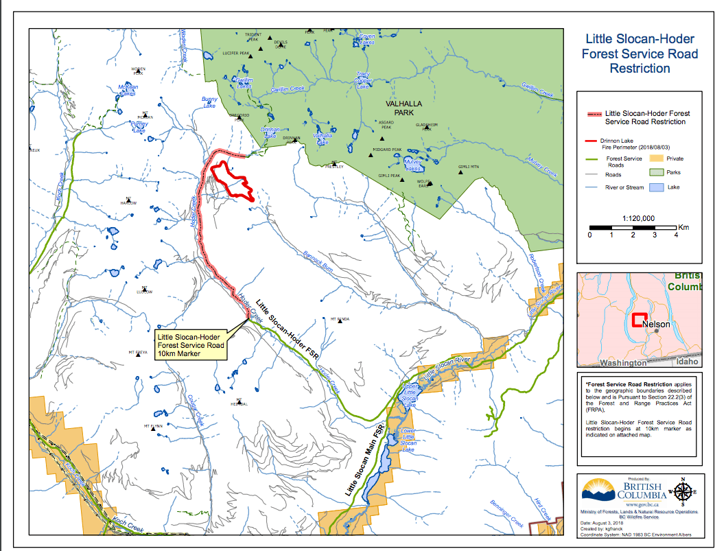
- The Little Slocan-Hoder Creek Forest Service Road is closed starting at the 10-kilometre mark. A detailed map of this closure is available online .
- The Meadow Mountain Forest Service Road is closed at the 28.1-kilometre mark. A detailed map of this closure is available online.:
- The Shannon Wragge Creek Forest Service Road, the Shannon Creek One Forest Service Road, the Slewiskin One Forest Service Road and the Shannon Caribou Forest Service Road are closed. A detailed map of these closures is available online at: http://ow.ly/I5zf30lojdw
- The Sheep Waldie Forest Service Road and the Sheep Billings Forest Service Road are closed starting at the 5.25-kilometre mark on the Sheep Creek Forest Service Road at the junction of Sheep Waldie and Sheep Billings Forest Service Road. A detailed map of this closure is available online at: http://ow.ly/CK4z30lrgxb
- An area restriction is in effect for the South of Renata Creek wildfire, in an area bounded by Dog Creek, Grass Creek, the Bulldog Eight Forest Service Road and the height of land connecting these perimeters. A detailed map of this area restriction is available online at: http://ow.ly/7fJr30lr1ye
- The Regional District of Central Kootenay has implemented a road closure for the Sheep Creek Road. The Sheep Creek Road is closed starting at its junction with the Aspen Forest Service Road. No public access is permitted. Contact the Regional District of Central Kootenay for further information about this road closure.
- The Lynch Creek Forest Service Road is closed. A detailed map of this closure is available online at: http://ow.ly/3ZQ830lqeW0
Columbia Fire Zone:
- The Beaverfoot Forest Service Road is closed, starting at the 47-kilometre mark (near the Symond Creek Bridge). A detailed map of this closure is available online at: http://ow.ly/fPsk30lbJBe
- The McColloch Spur Road is closed at its junction with the French Main Forest Service Road at the 11-kilometre mark. The entire Sweeper Bill Forest Service Road is closed at its junction with the French Main Forest Service Road at the 14.25-kilometre mark and the French Main Forest Service Road past the 14.25-kilometre mark is also closed. A detailed map of these closures is available online at: http://ow.ly/rfVG30loiRd
- An area restriction is in effect for the entire Groundhog Basin, immediately north of the French Forest Service Road and extending north to Old Camp Creek. A detailed map of this area restriction is available online at: http://ow.ly/Qy2F30loiSH
Invermere Fire Zone and Cranbrook Fire Zone:
- The Flathead Sage Creek Forest Service Road is closed starting at the 81-kilometre mark, at the junction of the Flathead Sage Forest Service Road and the Flathead Kishinena Forest Service Road. A detailed map of this closure is available online at: http://ow.ly/ZdUu30lomny
- The Cross River Forest Service Road is closed starting at the 10-kilometre mark of the Ravenshead Palliser Forest Service Road, and the Cross River Forest Service Road is closed to its junction with the Cross Mitchell Forest Service Road. The Kootenay River Forest Service Road is closed beginning at the 40.25-kilometre mark to the junction of the Kootenay River and Palliser Forest Service Road, and continuing along the Palliser Forest Service Road to the junction of the Palliser Forest Service Road and the Cross River Forest Service Road (by Nipika Lodge). The Ravenshead Forest Service Road is closed from the 44.75-kilometre mark to the junction of the Ravenshead Forest Service Road and the Palliser Forest Service Road. A detailed map of these closures is available online at: http://ow.ly/Oivc30lomo7
- St. Mary Lake Road is closed beginning at the 31-kilometre mark. The Redding Creek Forest Service Road is closed to the height of land on that road (including Grey Creek Pass). The Meachen Creek Forest Service Road and access to the White Boar Forest Service Road are closed starting at the 25.3-kilometre mark at its junction with the Hellroaring Forest Service Road. A detailed map of these closures is available online at: http://ow.ly/uJub30ln7LN
- The Horsethief-Forster Forest Service Road is closed starting at the 13-kilometre mark. The Horsethief-Dogleg Forest Service Road is closed starting at the 25-kilometre mark. The Hurst Creek Forest Service Road is closed starting at the 33.5-kilometre mark. A detailed map of these closures is available online at: http://ow.ly/iIk230lomqs
- The Coal Creek Forest Service Road is closed beginning at the 33-kilometre mark. The Leach Creek Forest Service Road is closed beginning at its junction with Corbin Road. The Morrisey Creek Forest Service Road closure begins at the 0.3-kilometre mark, at the junction with Morrisey Road. A detailed map of these closures is available online at: http://ow.ly/ymyt30lr91I
Road closures and area restrictions are subject to change, depending on wildfire activity. For the most current information, please visit the fire bans and restrictions section of the BC Wildfire website (for the Southeast Fire Centre) at: http://ow.ly/Zqz030lr94m
To report a wildfire or open burning violation, call 1 800 663-5555 toll-free, or *5555 on a cellphone. For the latest information on current wildfire activity, burning restrictions, road closures and air quality advisories, visit: bcwildfire.ca